
Glasgow to Paisley Section 1

Glasgow to Paisley spans 13.5 miles (22 kms) and is considered an easy route, making it a great option for those exploring Scotland pilgrimage paths. The terrain consists of footpaths, pavements, bridges, and busy roads, so care and attention should be taken when crossing roads. This walking route is a part of the scenic Whithorn Way, adding to its charm.
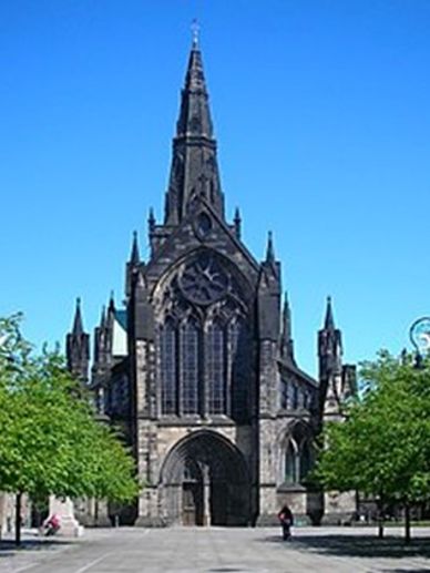
This is where your Scotland pilgrimage begins. Glasgow is a wonderful and vibrant city that you may wish to spend some time exploring before setting off on your walking routes. Glasgow Cathedral is located on the site where Saint Mungo, the patron saint of Glasgow, originally built his church, making it a significant stop on the Whithorn Way.
St Andrew's Cathedral

After leaving the Cathedral and walking down High Street as part of your Scotland pilgrimage, you will notice a mural painted on a building. This mural depicts a modern day St Mungo, created by Australian street artist Sam Bates, also known as Smug, and is a highlight along the walking routes like the Whithorn Way.
St Andrew's Cathedral
From the 'Squinty Bridge.'
St Andrew's Cathedral
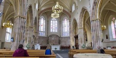
Along Clyde Street, you will see the splendour of St Andrew’s Roman Catholic Cathedral, a stunning Gothic Revival structure designed by Architect James Gillespie Graham and opened in 1816. This site is a highlight for those on a Scotland pilgrimage, especially for those exploring walking routes like the Whithorn Way.
Dolores Ibarruri .
From the 'Squinty Bridge.'
From the 'Squinty Bridge.'
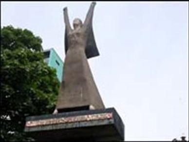
The walk along the River Clyde is outstanding, offering one of the remarkable walking routes in Scotland. As you stroll, you'll pass the monument of Dolores Ibarruri, a heroine and leader of the Spanish Republican and Communists movement, making it a meaningful stop on your Scotland pilgrimage that can connect to the Whithorn Way.
From the 'Squinty Bridge.'
From the 'Squinty Bridge.'
From the 'Squinty Bridge.'
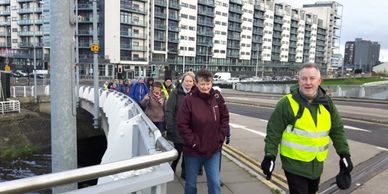
Walking over the Central Arc or ‘Squinty’ bridge, and along the River Clyde, you will notice some remains of Glasgow’s proud shipbuilding industry, a testament to the rich history of Scotland. As you continue on this scenic walking route towards Govan, just off your path, you will reach Govan Old Parish Church, which houses an amazing collection of Christian Stones, including Viking Hogback Tombstones.
After a while on this route, you will pass Braehead Shopping Centre, and as you head towards Renfrew, you follow the banks of the White Cart Water, passing by Renfrew Golf Club. This picturesque walk eventually leads you to St Conval’s Chariot and the Argyll Stone at the Normandy Hotel.
Take extra care when crossing the road near the Bascule Swing Bridge, then head onto Abbotsinch Road and pass Glasgow Airport. This long road will lead you into Paisley and to the historic Paisley Abbey, which was founded in 1163 as a Cluniac Monastery. It is believed that Saint Mirin established a community on this site in the 7th century, making it a significant stop on the Scotland pilgrimage.
Close by is St Mirin’s Roman Catholic Cathedral, built in 1931 near the site of an earlier Church from 1808, further enriching the historical tapestry of this area.
Paisley to Lochwinnoch Section 2
Section 2
Section 2

Paisley to Lochwinnoch 10 miles (16kms)
Grade: Easy.
Terrain: Footpaths and Cycle/Access trails.
As you embark on this journey, part of the Scotland pilgrimage, after leaving Paisley Abbey, you cross over the White Cart River at Bridge Street. Along the way, you will pass near St Mathews Church, renowned for its outstanding Art Nouveau architecture. www.paisleystmatthews.org/the-building.html.
Close to this Church, you will encounter a beautiful mural created by artists Mark Worst and Ross Dinnett, adding to the charm of the walking routes in this area. For more information about local art initiatives, visit www.paisleyfirst.com/projects/art-murals-projects. This route is also part of the scenic Whithorn Way, making it a delightful experience for walkers.
Section 2


Walking along the National Route 7 cycle/access path, part of the Scotland pilgrimage, you will come to Castlehead Cemetery, where Paisley’s famous Poet, Robert Tannahill is buried. www.poetsgraves.co.uk/tannahil. Continuing on the cycle/access path towards Lochwinnoch, which is among the popular walking routes, there is a fascinating tower situated to your left on top of Kenmuir Hill. www.lochwinnoch.info/history/local-tales/traditions-of-the-tower. Near Lochwinnoch, on your right, just off the route, is the stunning 16th Century Castle Semple Collegiate Church, a notable site along the Whithorn Way. www.ancient-scotland.co.uk/site.php?a=197


Lochwinnoch to Kilwinning Section 3

Section 3
Lochwinnoch to Kilwinning spans 13 miles (21kms) and offers an easy grade for those exploring the beautiful walking routes of Scotland. The terrain consists of footpaths, cycle/access paths, and minor roads, making it a pleasant part of the Scotland pilgrimage, especially for those following the Whithorn Way.
After leaving Lochwinnoch and following the cycle/access path, on your right, you will see Barr Castle, a well-preserved 16th-century castle. This area is part of the scenic walking routes that can be enjoyed along your journey through Scotland. Continuing on the cycle/access path, you will head towards Kilbirnie. Nearby, just off the route, is the Kilbirnie Auld Kirk, a 15th-century Pre-Reformation Church that stands on the site of an earlier church.
Heading towards Kilwinning on Blair Road, turn right before the Weak Bridge sign and continue on Blair Road to the Lodge House entrance gate. This route takes you through the stunning gardens of the Blair Estate, which are ideal for those on a Scotland pilgrimage. You are welcome to use the designated path, but please respect the privacy of the owners and refrain from wandering towards the main house. You will exit onto Blair Road, turn right, and rejoin the route. As you continue on to Kilwinning, take care on Blair Road due to blind bends going uphill.
Upon reaching your destination at Kilwinning, you will see in the distance the 12th-century Kilwinning Abbey, founded by the monks of the Tironensian Order. This historic site is an essential stop for those exploring the Whithorn Way and its significance in Scotland's rich heritage.
Kilwinning to Troon Section 4

Section 4
Kilwinning to Troon spans 12 miles (19 kms) and is an easy-grade route. This section of the journey offers a blend of terrain, including cycle/access paths, beach areas, and busy roads at Irvine and Troon. It serves as a wonderful part of the Scotland pilgrimage, particularly for those exploring popular walking routes like the Whithorn Way.
On leaving Kilwinning Abbey at Vault Lane, turn left onto Church Street and follow the Whithorn Way signs along the banks of the River Garnock, a popular route for those enjoying a Scotland pilgrimage. Continuing on, the walking route takes you to Irvine. At Irvine, you pass the Fullerton Connexions Church, a very welcoming center that offers toilets and a café, so be sure to check the notices for opening times. http://fullartonconnexions.co.uk/ Keep with the Whithorn Way towards Irvine Harbour. Continue walking along the coastal path to Troon or enjoy the long stretches of sands. You will pass one of the many excellent golf courses in this area before arriving at Troon, where there are beautiful churches to visit. St Ninians Scottish Episcopal Church, located at Bentinck Dr, Ayrshire, Troon KA10 6HZ, is designed in Arts & Crafts Gothic by James A Morris. Our Lady of the Assumption and Saint Meddan’s (Roman Catholic) at 4 Cessnock Rd, Troon KA10 6NJ showcases Gothic Revival architecture. Portland Parish Church (Church of Scotland), found at 2 St. Meddans Street, Troon, KA10 6JU, features a Perpendicular Gothic style. Finally, Troon Old Parish Church (Church of Scotland) at Ayr Street, Troon, KA10 6EB exemplifies Neo-Gothic architecture.
Troon to Ayr Section 5

Section 5
Troon to Ayr 9.5 Miles (15 Kms) Grade: Easy Terrain: Cycle/ Access paths, beaches, busy roads i
Stay on the Whithorn Way, a popular Scotland pilgrimage route, or walk on the stunning beach alongside the Royal Troon Golf Course towards Ayr.
Just before Prestwick Holiday Park, you must come off the beach to pass the Park. After passing the Prestwick Holiday Park, you can continue along the beach or follow the Ayrshire Coastal Path, both of which are beautiful walking routes.
On your left at Prestwick, you will find the remains of St Nicholas’s Church.
Just after the sailing club, take a left onto Maryborough Road. This slight detour from the Whithorn Way leads to Bruce’s Well, St Ninian’s Chapel, and the Leper Hospital.
Retrace your steps back onto the Whithorn Way and continue to Newton-on-Ayr, making your way towards the main town of Ayr.
Ayr is home to many beautiful churches, such as:
The Cathedral Church of Saint Margaret,
Architectural Style: Gothic
27 John St, Ayr KA8 0BS
St Leonard’s Parish Church,
46 St. Leonards Rd, Ayr KA7 2PT
Architectural Style: Geometric period of Decorated Gothic
One of Ayr's many historical attractions is the beautiful 12th Century Church dedicated to St John the Baptist, known as St Johns Tower.
Leaving from St John’s Tower, walk along Cassillis Street, leading onto Charlotte Street. Turn left onto the Esplanade and continue to follow the Whithorn Way. In the distance, you will see the ruins of Greenan Castle.
Ayr to Maybole Section 6

Section 6
Ayr to Maybole is a 13-mile (21 km) journey that forms part of the scenic walking routes in Scotland, including the renowned Whithorn Way. This route is graded as moderate and features a variety of terrain, including cycle and access paths, rocky shorelines, tidal waters, and steep ascents over Carrick Hill, making it a noteworthy section for those on a Scotland pilgrimage.
Follow the beach at Ayr and turn left just before the little bridge at River Doon, which takes you onto Greenfield Avenue, turning right at the B7024 towards Alloway cricket ground.
From the Heritage Centre, cross the road on Murdoch’s Lone and take the path on the right. This path takes you under the B7024. Here, you can join the Whithorn Way route along the old Railway Line, known for its scenic walking routes, exit at Dunure Road, and walk towards the shoreline, taking care when crossing the A719.
Heading towards the shoreline, turn left towards Dunure, passing Craig Tara Holiday Park. Note that high tides at the Heads of Ayr may block the shoreline walk.
(If you are unsure about walking over the rocky outcrop on the tidal coastal route to Dunure, you can skip Dunure and walk along the A719, taking a left going up to Carrick Hill, just after the Heads of Ayr Family Park. This route is suitable for both walkers and cyclists and leads you to Maybole, offering a lovely experience over Carrick Hill, although be mindful of traffic on the A719.)
From Dunure, at Castle Road, continue onto Station Road. Follow Station Road until you meet A719, Ayr Road. Cross the A719 diagonally to the minor road at Fisherton Primary School.
Follow the road and turn right at the T Junction, then take the first left. Continue walking through the track and woodland. (This is quite a rugged and overgrown route and may be unsuitable for bicycles.)
This path leads onto a minor road, which takes you to Preaching Brae; carry on until you come to a crossroads, continuing across the road at Ladycross. This is a beautiful, long, and winding walk into the Carrick Centre, making it a great stop on your Scotland pilgrimage.
The Carrick Centre is a Church of Scotland, multi-functional, modern, flexible, and welcoming church, complete with a cafe.
Nearby is the Maybole Collegiate Church. https://www.historicenvironment.scot/visit-a-place/places/maybole-collegiate-church/
Our Lady and St Cuthbert's Roman Catholic Church, founded in 1878, is closely modeled upon that of the Benedictine Monastery of Crossraguel, located at 28 Dailly Rd, Maybole KA19 7AU.
Maybole to Girvan Section 7

Section 7
Maybole to Girvan covers 12 miles (19 kms) and is one of the enjoyable walking routes along the Scotland pilgrimage. The terrain is easily navigable alongside a busy road, featuring paths and tracks. The duration for this scenic walk is approximately 5-6 hours, making it a delightful section of the Whithorn Way.
On leaving Maybole, walk on the pavement along the A77. Continue down this road until you reach Crossraguel Abbey, a notable site for those on the Scotland pilgrimage. Take care when crossing the A77.
www.historicenvironment.scot/visit-a-place/places/crossraguel-abbey/
After visiting Crossraguel Abbey, continue along the A77, being extra cautious on this section as there is no footpath. Turn left after the farm entrance and stay on this road until you reach the ford crossing (use the side crossing on your left, so there's no need to wade through the water). After crossing the ford, turn right, then left to head towards Kirkoswald on the A77.
As you make your way to Kirkoswald, consider stopping at Souter’s Inn, a lovely restaurant nearby. You can also explore the remains of Kirkoswald Old Parish Church and its graveyard, which add to the charm of the walking routes in this area.
Not far from the main road is Souter Johnnie’s Cottage, a site cared for by the National Trust for Scotland, perfect for those interested in historical landmarks.
www.nts.org.uk/visit/places/souter-johnnies-cottage
Just past Souter Johnnie's, turn left up Kirkbrae, passing Kirkoswald Parish Church. This church is particularly unique, as its design was influenced by Robert Adam, one of Scotland's outstanding architects.
Turn right at the main road and follow the Whithorn Way to Ladybank Steading Farm. Take care when crossing the A77, then turn left at the cottages leading to the shore. Follow the shore and walk through Girvan Mains Farm. Finally, continue along the Whithorn Way into Girvan Harbour.
girvan to colmonell SECTION 8

SECTION 8
Girvan to Colmonell 10.5 Miles (17 Kms) is a great section of the Scotland pilgrimage, taking you through various walking routes. The terrain features beaches, alongside the busy A77, minor roads, grass, and possibly muddy underfoot conditions. Allow 4-5 hours to complete this leg of the journey on the Whithorn Way.
On leaving Girvan Harbour, follow the beach/path as part of the Whithorn Way, a notable route for those interested in Scotland pilgrimage. Continue towards the A77, where you'll find Public Toilets in the large car park nearby, along with a little Takeaway Café. The A77 has a narrow footpath, so take extra care as the footpaths end, and you will need to walk on the grass verges. After passing Ardwell Farm, take the next left, which is signposted for the Ayrshire Coastal Path. This section used to be the old coach road and can become muddy after heavy rain. This quiet walking route leads you to Lendalfoot. As you descend into Lendalfoot, be cautious when exiting the footpath to rejoin the A77, which will take you directly into the village. Lendalfoot is a lovely picturesque village, perfect for a lunch break on the charming benches beside the rocky beach. After leaving Lendalfoot, turn left towards Colmonell at the Community Centre. This route features a steep climb of over 400 feet on a quiet minor road, where you can glimpse the ruins of Carleton Castle. Continue along the single track road until you descend towards the Pinbraid Trout Fishery, soaking in the wonderful and beautiful scenery. After the descent, you'll reach a T Junction; turn right onto the B734 over the Garnaburn Bridge. Continue on the B734 until you reach Main Street, Colmonell, home to St Colmon’s Parish Church.
Colmonell to Barhill Section 9

Section 9
Colmonell to Barrhill: 9 Miles (14.5 kms)
Grade: Moderate
Terrain: Minor roads, Tracks, Fields (possible cattle) Uneven ground. Muddy underfoot.
Duration: 4-5 Hours.
This section of the Whithorn Way is a fantastic part of the Scotland pilgrimage, offering enjoyable walking routes through picturesque landscapes.
Leaving Colmonell from St Colom’s Church, turn right between the houses and head towards the River Stinchar behind the woods, then turn left and follow the river along this picturesque walking route, which is part of the Scotland pilgrimage.
Walk along the banks of the River Stinchar.
At Craigneil Road, turn right over the Colmonell Bridge, then continue first left.
On the road to Pinwherry, cross over Glenside Bridge. At the Y junction, keep left and pass alongside Dalreoch Mains Farm.
Keep on this track until you come to an open field, then head towards a gap in the trees.
Entering another field, keep to your right edge, especially if there are cattle in the field.
Continue to A714. Turn left to Pinwherry.
Head towards the bridge at Pinwherry.
After crossing the bridge at Duisk River, turn right, passing Pinwherry Primary School on your left. This may make a nice picnic lunch stop near the Community Centre as you enjoy the walking routes of the area.
Continue on this minor road, passing Fardenreoch Farm.
Shortly after Liglartrie Farm, you approach Muck Bridge crossing Duisk River. Turn right at the T junction next to the derelict cottage.
Continue to Glenduisk Farm, heading uphill and follow the road around at the hairpin bend.
Follow this road through the ribbon wood. Then take a sharp right to Belhamage Farm.
(Just after the Ribbon Wood, head towards Belhamage Farm. This is a shooting farm, so please keep to the path.)
Keeping on the main track to Liglaw Wood, stay on track towards the outskirts of Kildonan House with Glen Wood on your left and Duisk River on your right.
At the end of the track, turn right, leading to Main Street A714 to Barrhill, continuing your journey on this scenic route that is reminiscent of the historic Whithorn Way.
Embarking on a Scotland pilgrimage can be a transformative experience, especially when exploring the scenic walking routes like the Whithorn Way. This trail not only offers breathtaking views but also connects travelers with the rich history of the region, making it a perfect choice for those seeking both adventure and spiritual reflection.
Barrhill to new luce. Section 10

Section 10
The walking route from Barrhill to New Luce spans 13 miles (21kms) and is considered moderate in grade. This section of the Whithorn Way offers a variety of terrain, including tracks and woodland paths, though be prepared for muddy conditions underfoot. As you traverse the single track roads, take care to watch for traffic, especially agricultural vehicles, making it a notable part of your Scotland pilgrimage.
From Barrhill, you would typically take the riverside track on the left side of Cross Water Burn (signposted) to reach the Martyr’s Tomb, a noteworthy stop along the Scotland pilgrimage. However, due to recent tree clearance, this route is currently unsafe for walking.
It is advisable to access the Martyr’s Tomb (signposted) from Gowland’s Terrace, crossing at a small wooden bridge.
After visiting, retrace your steps back to the road and turn left up the hill, passing Barrhill Railway Station. Continue along this minor road and cross over a beautiful bridge at Cross Water.
On your right, you will notice the charming and picturesque railway signal box at Glenwhilly. This long stretch of winding road through moorland offers a stunning and rugged landscape in all seasons, making it a delightful segment of the walking routes associated with the Whithorn Way.
Continue on this single-track road until you reach Dirniemow Bridge at the Cross Water of Luce. Turn left across the cattle grid and remain on the single-track road.
Continue straight on past Knockiebae Farm, which takes you into New Luce. Proceed to the bridge at Main Street.
Follow Main Street to the New Luce Memorial Hall, where you can find toilet facilities, though they have limited opening hours.
Embarking on a Scotland pilgrimage can be a transformative experience, especially when exploring the scenic walking routes like the Whithorn Way. This trail not only offers breathtaking views but also connects travelers with the rich history of the region, making it a perfect choice for those seeking both adventure and spiritual reflection.
New luce to mochrum Section 11
Section 11
New Luce to Mochrum. 21.5 Miles. (34.5 Kms)
Grade: Moderate to challenging.
Terrain: Minor Roads, Tracks, Woodland Paths, Moorland, Muddy Paths.
Duration: 8-9 Hours (This section of the Scotland pilgrimage can be adjusted to suit each walker. You may wish to split this section into two stages along the walking routes and use the local taxi service to pick you up and drop you where you finished the previous day, especially when exploring the Whithorn Way.)
Leaving the Memorial Community Hall, head past the New Luce Parish Church as you embark on one of the scenic walking routes of Scotland, particularly the Whithorn Way.
As you stroll along this picturesque road, be mindful of traffic on the road beside the Water of Luce.
On your right, you'll find Glenluce Abbey. Be sure to check their website beforehand for opening hours: https://www.historicenvironment.scot/visit-a-place/places/glenluce-abbey/prices-and-opening-times/
After leaving Glenluce Abbey, turn right onto the main road. Continue and take the next left onto the field track, following it to Church Street. Cross Main Street and head directly across to Bankfield Road, leading to the A75.
At the end of Bankfield Road, turn left to walk to and use the underpass (do not attempt to cross the A75, as it is a very busy and fast road). After crossing the A75, turn right, then follow the path to the left and continue on the single track road, passing Barlockhart Loch on your right.
As you continue through this stunning agricultural landscape, you will reach Milton Bridge. Follow this road until you reach Kirkchrist Bridge, then turn left at the T junction. Stay on this road until you reach a crossroads, taking extra care as you go straight across the A747.
Follow this farm track, which merges with the single track road to Whitefield Loch. Continue on this road, passing the beautiful Whitefield Loch on your left. At the car park at Whitefield Loch, continue straight ahead, passing cottages on your left.
At the junction, continue straight on, bearing left at Culroy Farm. Continue on this road, with woodlands on both sides. White Loch is hidden behind the trees.
As you exit the woodland at Challochglass Moss, continue straight on this path and turn right at the T junction. Follow this road, with Fell Loch on your left, and continue along until you reach Loch Hempton, which is very close by.
Continuing on this route leads you to the picturesque Old Place of Mochrum on your left, with the stunning Mochrum Loch on your right. Follow the road alongside the scenic Mochrum Loch and past The May Farm.
Turn left at the T junction onto the B7005, signposted to Mochrum. At the derelict Culshabbin School House, take the farm track almost opposite on the right.
As you head along this track, you will pass the outskirts of Elrig House, the birthplace of author and naturalist Gavin Maxwell. Continue through the public footpath at Airylick Farm.
Keep an eye out for an ancient Celtic Stone used within the farm building at Airylick. Shortly after Airylick, turn right to visit the remains of Barhobble Church: https://ecoartsblog.wordpress.com/2013/07/06/barhobble-church-ruins/.
Retrace your steps and follow this road, turning right onto Main Street to Elrig. Keeping left, pass the Old Mill House. At the Y junction, keep left, uphill to Mochrum, passing Swallow Cottage.
At the T junction, turn left onto Main Street and visit Mochrum Parish Church: https://en.wikipedia.org/wiki/Mochrum.
Mochrum to Whithorn Section 12

Section 12
Mochrum to Whithorn, a distance of 9 miles (14.5kms), is an easy walking route that forms part of the popular Scotland pilgrimage. The terrain consists of minor roads, so be cautious of cars and agricultural vehicles along the way.
Leaving Mochrum Parish Church, turn right and then take the first right. Follow this road and at the T junction, continue straight ahead. Continue along this single track road, passing Felyennan Farm. At the next T junction, carry straight on. Turn left at the following T junction onto B7021. Continue on this road, crossing Burnside Bridge. At the T junction, turn right onto B7085 and enjoy the tree-lined scenery as you travel. Keeping to the left at the Y junction, continue on the B7021. Follow this road, passing the Monreith Mains Workshop, and keep going on the B7021, where you will see the Drumtroddan Standing Stones in the field on your left. Retrace your steps to the B7021 and head left towards Whithorn. This long stretch of road offers wonderful views of the very best of farming in Dumfries and Galloway, making it a great addition to your Scotland pilgrimage. Continue on this road and pass a small bridge at Monreith Burn. Just after Bishopton Farm, turn right onto A746 St John Street. Follow this road onto George Street, where you will find the Whithorn Story and Passport Office, which features a lovely café and gift shop. Nearby, you can visit the Roman Catholic Church of St Martin and St Ninian, as well as the Church of Scotland St Ninian Priory. Close by is the historic Whithorn Priory, which is a highlight for anyone exploring the walking routes along the Whithorn Way.
WHITHORN TO THE iSLE OF Whithorn section 13

Section 13
The walking route from Whithorn to the Isle of Whithorn via St Ninian’s Cave spans 11 miles (18 Kms) and offers a moderate grade for hikers. This section of the Scotland pilgrimage features diverse terrain including tracks, fields, a rocky beach, and a cliff edge. Notably, the path from St Ninian’s Cave to the Isle of Whithorn includes a cliff edge walk for about a mile, making it suitable only for sure-footed walkers, as some sections may have overgrown grass. Expect to spend approximately 5-6 hours completing this scenic part of the Whithorn Way.
The section from Whithorn to Rispain Camp is of recent construction, with the remaining section to St Ninian’s Cave to follow shortly, making it a great addition to the Scotland pilgrimage routes.
On leaving the Whithorn Trust at George Street, turn right through the Pend onto Bruce Street.
Turn left just before St Ninian’s Priory. Take the first left to Rispain Camp through the metal access gate.
Continue on this path, keeping to the left of the Ket Burn.
After continuing on the path, you will cross the Ket Burn at a small wooden bridge.
Continue on this track until you reach the historical Rispain Camp, which once served as a settlement for Iron Age roundhouses.
Retrace your steps along the track, alongside Rispain Farm.
Turn left onto A746 at Rispain Cottage.
Then turn right onto a track with the woodland on your left.
Continue on this track, going through the Half Moon woodland.
Exit the woodland onto the road, turn right, and continue to the crossroads. Take the first left opposite the war memorial.
At the Y junction, bear left, passing near Glassterton Churchyard.
Follow this track until you reach a minor road. Turn right before you reach Claymoddie Farm.
Continue down to the cliff edge. Turn left and follow the coastal path.
Walk along the coastal path, then bear left to the Glen Plantation woods on your right.
Turn right through the woods to a track and follow the shoreline. Turn right along the beach to St Ninian’s Cave.
On a clear day, you can see the Isle of Man from the shore.
Leaving St Ninian’s Cave, turn left and walk along to the end of the beach until you meet the next cliff.
You have a short steep climb to the top of the cliff.
Be very careful walking along the cliff edge. This cliff path lasts for about a mile, then opens to a wider pathway.
Continue on this path as you meander towards Burrowhead campsite, a part of the popular walking routes in the area.
This is an idyllic walk, where you will see breathtaking views of rock formations, caves, wildlife, flora, and fauna.
On reaching Burrowhead Caravan Park, keep to the path on the outskirts of the Caravan Park and follow the path along the top of the cliff.
(Burrowhead Caravan Park site was originally used as a training camp for anti-aircraft gunners during WW2. Some evidence of this can still be seen.)
If using your mobile phone around this area, your mobile phone provider may assume you are on the Isle of Man, where the strongest mobile phone signal is situated.
Continue along the cliff edge until you reach the Isle of Whithorn Village.
Follow along the edge of the harbour and exit onto Main Street from the side of the cottages.
At Main Street, turn right, and at Harbour Row, turn right again.
Follow this road, turn left at the car park, and head towards St Ninian’s Chapel.
Embarking on a Scotland pilgrimage can be a transformative experience, especially when exploring the scenic walking routes like the Whithorn Way. This trail not only offers breathtaking views but also connects travelers with the rich history of the region, making it a perfect choice for those seeking both adventure and spiritual reflection.